


Anchor Alarm - SailGrib AA
Descrição do Anchor Alarm - SailGrib AA
Anchor Alarm da SailGrib, é um aplicativo de alarme de âncora moderno e completo.
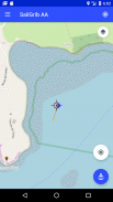
- Inicie o aplicativo antes de sua âncora, o aplicativo irá registrar e desenhar sua trilha em um mapa.
- Deixe seu telefone na mesa de gráfico.
- Moore sem se preocupar com o aplicativo.
- Retorne ao aplicativo.Na pista, localize o ponto correspondente à posição do barco no momento do fundeio. Você deve ser capaz de detectá-lo com relativa facilidade no mapa, graças ao movimento reverso após a ancoragem.
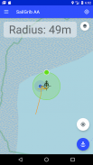
- Centralize o mapa no ponto de ancoragem usando o sinal de destino no meio da tela.
- Pressione o botão azul "Âncora" para fixar a posição da âncora.
- Ajuste o raio da área de umedecimento movendo o ponto verde para a borda da zona.
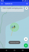
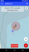
- Fixe a área de umedecimento pressionando novamente o botão "Ancorar", que fica verde. O alarme é ativado.
NOVO: Use suas cartas náuticas Navionics dentro do app!
Com a opção Premium:
- Defina uma zona de umedecimento hexagonal e editável na tela.
- Envie um e-mail quando um alarme for acionado.
- Ver mapas WR SailGrib.
- Importe o traço GPX do SailGrib WR se você esqueceu de iniciar o aplicativo antes de molhar.
O aplicativo é executado em segundo plano e usa as técnicas mais recentes do Android para reduzir o consumo de energia e, ao mesmo tempo, maximizar a precisão da posição.
Observe que a precisão da sua posição depende do seu telefone e da sua localização. Em março de 2021, consideramos que a maioria dos telefones tem uma precisão entre 2 e 10 metros no mar.
Anchor Alarm - SailGrib AA - Versão 3.2
(06-10-2023)Anchor Alarm - SailGrib AA - Informações do APK
Versão do APK: 3.2Pacote: com.sailgrib.anchoralarmÚltima versão de Anchor Alarm - SailGrib AA
Outras versões


 3.38
3.38 3.98
3.98

Apps na mesma categoria

Você também poderá gostar...


